

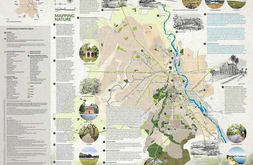
The ecological map of Delhi
Delhi’s greener past: A map to make us think
Geeta Wahi Dua & Brijender S. Dua, New Delhi
Look around you in Delhi and the city seems to be teetering on the brink of hopelessness. A dying river, fragmented forest cover, dilapidated lakes and water tanks, open sewers, severe air pollution — matters appear to have gotten to the point where it has become difficult to imagine that they could get worse.
But gloomy as the present might be, stepping back in time reveals a Delhi that was quite different. It is instructive to see how the city took shape over centuries by managing its natural resources well. There was respect for topography and a willingness to fit in with nature. The Yamuna was a lifeline and waterbodies and canals served as its extensions.The Ridge enjoyed respect as the tail-end of the Aravalli’s and served as a verdant boundary and lung.
Could the urban chaos of today have been avoided if this harmonious approach had been adopted as urban pressures grew? Is it possible that if the long-forgotten past of Delhi were to be revisited and better understood, the future of the troubled city that we now struggle to live in could be different?
Residents have been trying in their own homely ways to restore some balance. They have been working at reviving tanks and ponds. There are efforts to increase green cover. From time to time the Yamuna gets attention. But what if a map of Delhi were to provide a ready reckoner of the important resources and systems that once served the city well? Would it provide better focus and enable us to undo some of our mistakes more purposefully?
A map plots what we can’t see. It helps us figure out where we are. It also helps us choose the directions in which we can go. It serves as a record that future generations can turn to.
 Landscape Foundation, a landscape research studio, has conceptualised the Delhi Nature Map to trace the growth of the city over 12 centuries, specifically in the context of its changing relationship with nature. Most modern cities have sought to deal with the problems of over-urbanisation by reworking their relationships with nature. Perhaps Delhi could do the same and would be well served by a historical perspective.
STORY SO FAR
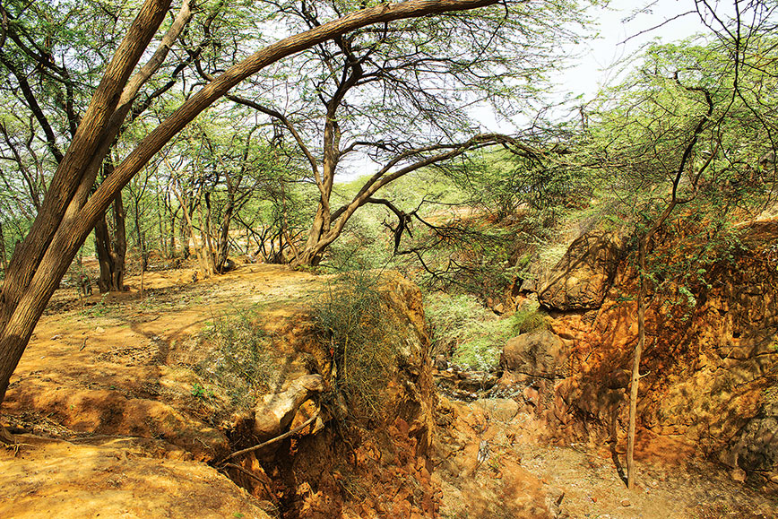
The city of Delhi is precariously positioned in the context of two prominent natural features. There is the Ridge, which consists of forests in the foothills of the Aravalli range of mountains entering the city from the south and leaving it near the north. There is also the Yamuna, which flows on the eastern fringe. These two features, with distinct topography, soil type, hydrology, microclimate and vegetation form a diverse landscape.
The earlier settlements of Delhi including Lalkot, Dehli-e-Kunha, Siri and Tughlaqabad were established in the southern ridge forests while the cities of Ferozabad, Purana Qila and Shahjahanabad were founded on the western river bank. In the early 20th century, the new capital city of New Delhi was conceptualised on the site that linked the central part of the Ridge to the river. The city has now grown in all directions, even across the river on the lower eastern side.
In the history of Delhi, there was a self-sufficient public system of water management with natural streams, channels and ponds, many of them draining off into the Yamuna on the east.
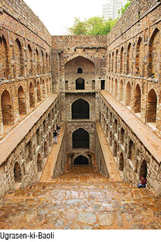
Water-harvesting in the arid and dry region was given due value in imperial building projects — tanks (Anangtal, Surajkund, Hauz Khaz, Hauz-e-Shamshi), baolis or step-wells (Ugrasen ki Baoli, Gandhak ki Baoli), moats around forts (Tughlaqabad and Adilabad) and barrages and bridges over water channels (Athpula, Satpula, Barapulla).
The topography of the region with the forested area of the Ridge had landforms and natural slopes which were conducive to the formation of such local water-harvesting structures. In earlier settlements, the river Yamuna, turbulent in nature, was never envisioned as the prime source of water supply. Later, when the imperial capital with settlements shifted towards the riverfront (Ferozabad, Purana Qila and Shahjahanabad) the scenario changed.
With the population shifting to the northern side of the city, the Western Yamuna canal, (coming from northern Hissar) constructed in the period of Feroz Shah Tughlaq along with traditional wells and a few baolis became sources of water supply to these cities.
The traditional water structures, located on the southern side of the city, were abandoned. Large water bodies such as the Najafgarh jheel, a wetland, dried up over time.
Under the British, with the Yamuna becoming one of the main sources of water supply to the city, the decline of the water system that had survived for more than five centuries, started and never recovered.
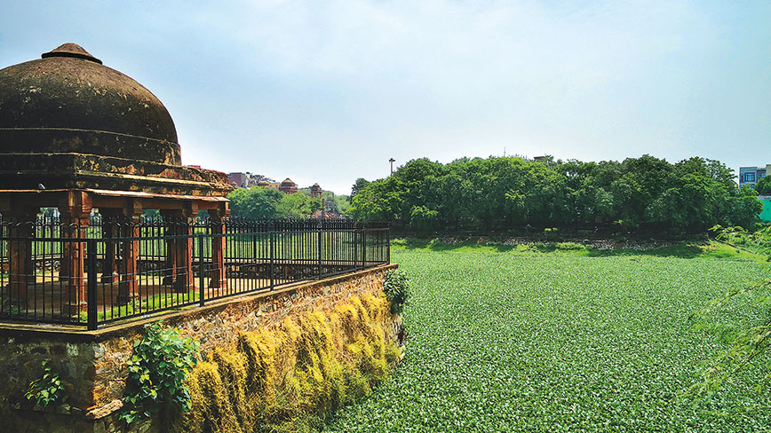 The Hauz-e-Shamsi
Coming to the other prominent natural features, the role of the Ridge forest in the city till the late 19th century was ecological, productive and recreational. It was the site of the earlier settlements of Delhi with orchards (Mehrauli), hunting grounds (Mahipalpur, Malcha) and agricultural fields. It gradually fell prey to rampant clearing by the British and later to their afforestation drives of exotic species. The trend has continued.
Rapid urbanisation, accompanied by indiscriminate and unscientific denudation, has made the forest fragmented, causing severe damage to its natural flora and fauna and its ecological cycle. Despite rules and regulations, the exploitative relationship that the city gradually established with the river Yamuna and the Ridge has persisted.
WAY FORWARD
There is an urgent need to rediscover the natural assets of the city and take strong measures to save them for posterity while creating ecologically sensitive living environments. Before we think of reviving them, it is important to understand that with changing contexts, the inherent character of these ecologically significant elements have undergone drastic changes. These need to be looked at, taking into account their new physical and ecological contexts.
Climatic conditions are different now. With the drastic increase in population, the city has grown in all directions. The city has a democratic government. All these socio-economic and political factors over time make it amply clear that it is not possible to bring back the original natural character of the city, but the role and significance of these elements in the revival of the environmental health of the bursting metropolis remains unquestionable.
RIVER YAMUNA
The first and foremost step in reviving the river is to allow a steady and adequate perennial flow in it. Flowing water dissolves soluble compounds and transports alluvial and dissolved sediments, enriching the floodplains by depositing silt and sediment, while maintaining its water quality. The path of the river through the city is but a part of its journey through a land with no boundaries. Its core character of flowing upstream through the city and downstream needs to remain the same.
Secondly, floodplains with alluvial soil are ecologically significant areas and are sources of sub-surface water, especially during the monsoon season. They are the sites of diverse riparian flora and fauna. As buffers they allow the river to expand during the monsoons when the flow is maximum thereby minimising flood threats. There is an urgent need to conserve the floodplains of the river against any construction activity.
Thirdly, the Yamuna is the carrier of most domestic, agricultural and industrial waste that comes through more than 20 city drains that pour into it. It is critical to ensure that these effluents are treated in sewage treatment plants (STP) before being released into the river. The idea of wetlands along the river where polluted water is treated by a bioremediation system of ponds, filters and swales before being poured into the river, may also be explored. All these measures, in an integrated manner, will contribute to reviving the river and maintaining its ecological health.
TRADITIONAL WATER STRUCTURES
Traditional water systems of the city in the form of baolis, lakes and tanks need to be rejuvenated taking into account their existing context. The tanks and lakes can become catchment areas of surface runoff and treated sewage effluents from surrounding areas, so that they have enough water with appropriate BOD (biological oxygen demand) levels throughout the year. This will help in recharging the groundwater regime. Instead of depending entirely on the river for water supply, the existing lakes can become sources of water supply to small local settlements. Regular desilting, weed removal and aeration methods will keep these water features alive and healthy. All city drains, isolated, interconnected or connected to the river should become ecologically reserved areas, free of any encroachment or part of reclamation land parcels.
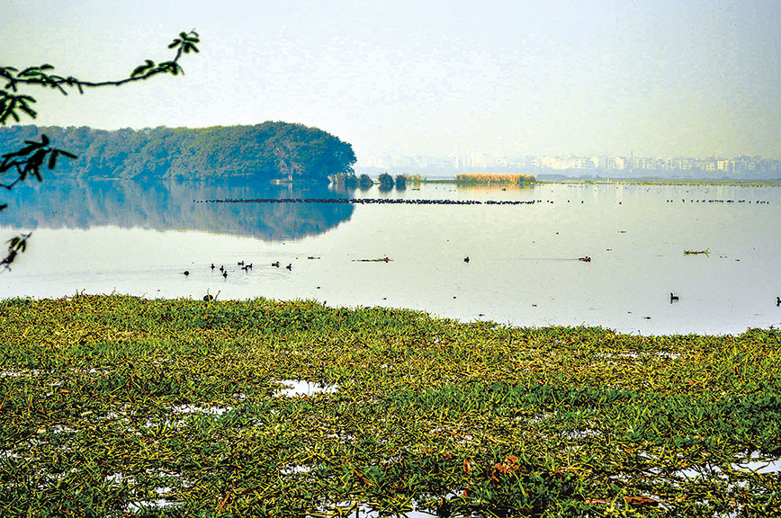 The bird sanctuary at Okhla near the Yamuna
They may be developed as wetlands where sewage effluents from neighbourhoods are treated by various bioremediation measures and other techniques. Each of these neighbourhoods, in collaboration with local authorities can have its own strategy to catch the maximum amount of surface runoff during the monsoons. Such water recharges open storm water drains, which, acting as a wetland, either recharge the groundwater or take the treated water down to a nearby lake or tank or baoli.
Since most of the drains are non-functional, the city is waterlogged even after light monsoon showers. Such a hierarchical and integrated system of storm water management, starting from the neighbourhood level is the need of the hour.
Once the challenges of quality and quantity of water are addressed, each of these water structures can become part of a live water museum where people can understand their significance and value in the past and present times.
RIDGE FOREST
Declaring the Ridge as a reserved forest was a big step in giving legal protection to this natural feature against any further development or encroachment. As mentioned earlier, the British, in the early 20th century, introduced many exotic species of trees including Prosopis juliflora (vilayati kikar). An invasive species, it grew vigorously in a short time, covering a large part of the Ridge and changing its ecological character.
Afforestation measures may focus on species of trees which are native to the Aravalli region. There are many varieties including Dhak (Butea monosperma), Pilu (Salvadora persica), Babul (Acacia nilotica), Karil (Caparis decidua), Ber (Ziziphus nummularia), Phylahi (Acacia modesta) and Hingot (Balanites aeqyptiaca). This will bring back the intrinsic character of the forest along with its biodiversity.
The conversion of parts of the Ridge into manicured lawns and parks planted with exotic varieties which require intensive use of water, needs to be immediately stopped. Where the forest is surrounded by residential areas, parts of it can be sensitively developed with native species in a regulated way while maintaining the natural topography with features like ridges, streams and rivulets.
ECOLOGICAL MASTER PLAN
An Ecological Master Plan (EMP) is a comprehensive dossier comprising of natural resources and use-guidelines for ecologically sensitive and culturally important natural and manmade features of the city. Documentation will include detailed description of each site including mapping its physical boundaries, salient features, history and ecological and cultural significance. Various spatial-planning software and advanced techniques of remote sensing will enable tracking each change and keeping updates.
Conservation and use guidelines will comprise the other part of the dossier. These guidelines, framed by experts (with structured public participation) will specify the long-term and short-term uses, functions and conservation measures for each site. They need to be strongly backed by a framework of laws passed by the state and central government.
 Delhi’s Ridge is its green lung
All development agencies need to work under the common umbrella of an Ecological Master Plan (EMP). The EMP can become part of the Delhi Master Plan 2021 or it can remain a separate entity. With the involvement of groups of experts and professionals, citizen groups and official departments, such a dossier will go a long way in enhancing the natural character of the city.
THE PROCESS
Being the capital city and an important urban centre, Delhi’s history and transformation over centuries is well-documented. There are many old maps of the city that provide information of the physical character and chronology of its growth. At the same time, there is limited documentation in history about its natural features and their relationship to different cultures. So, it was a challenge for us to cull relevant data from the extensive knowledge available on the city and weave a narrative for the first section of the map, which is the Journey so far.
We made a shortlist of archival maps and illustrations from various historical eras to serve our purpose, including Murray’s Handbook (1901, 1906), Survey of India Maps (1807, 2010, 2016), Brill Publications and Cambridge University Press, among others.
While referring to them we created hand-drawn maps and sketches with the focus of establishing the link between nature and culture that allowed us to bind the whole narrative, starting from historical times to the present, in a comprehensive way.
Mapping Nature, the second section, is about the present condition of the city. We created a base map with natural features, topography, significant open areas, city forests and the course of the Yamuna by filtering selected features from the Survey of India Open Series Map. We referred to the Eicher Map and Google Earth Map to add main elevations with respect to mean sea level, data for main roads, parks, greens around monuments and ecologically significant sites and to verify the extent and location of some of these sites.
Interpolation of these maps along with other information, gave us the final picture. The routes of the Delhi Metro rapid transit system are marked on the map to orient the readers. It was an exhilarating learning exercise. Each line drawn introduced us to a new facet about the city.
Along with these digitally-created graphics, we developed hand-drawn maps and sketches so that the exhaustive information given does not overwhelm. We have done our best to make the map reader-friendly and easy to comprehend.
Today, all parts of the city of Delhi are well-connected and one can visit almost all areas shown on the map, even the remotest parts. We visited traditional water-harvesting structures, the old cities of Delhi, the Yamuna riverfront, the Ridge forest, gardens and memorials to document our understanding of the landscape of the city.
 Areas like the Lutyen’s Bungalow Zone, Central Vista and various historic gardens and precincts are integral to our lives — we visit them for leisure, study them for our academic and professional involvements and travel through them every day. A few of these sites were shortlisted for sketching and photography.
Our research has been a multidisciplinary exercise which has immensely benefitted by useful inputs and suggestions provided by Dr Sunil Kumar and Dr Narayani Gupta, who are eminent historians; Awadhendra Saran, an expert in rural and urban sociology; Manoj Misra, environmental activist, Yamuna Jiye Abhiyaan; Malavika Karlekar, the well-known author; and Dr C.R. Babu, scientist and ecologist. There were many friends and well-wishers whose inputs were invaluable.
TIMELINES
We started working on the map in the months of January-February 2017. We began by understanding the city’s history in the spatial-ecological context by reading books on its history and meeting resource people. The project progressed from there. It took us six months before we were ready with the first draft, which was later fine-tuned after taking inputs from experts.
The funding of such research documentation projects is crucial, but we were also clear that this important work should not stop on this account. We tried a crowdfunding platform, with partial success. Friends, colleagues and well-wishers made donations for the project.
We would like to note here that it is challenging for a research studio like ours to develop a sustainable model of funding, and we are on the lookout for companies and other agencies which share our vision and are ready to support such projects.
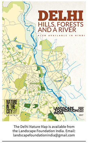
In our world of imagination, creativity and intellectualism, we tend to forget that people are the soul of discourse. Research of this kind needs to be accessible to common citizens, set them thinking and spur them to action. The map has been conceptualised as a set of bilingual flyers in English and Hindi.
Geeta Wahi Dua and Brijender S. Dua are editors of LA Journal, a quarterly publication on landscape architecture and allied fields in the Indian subcontinent. With a background in landscape architecture and architecture, they also conceptualise diverse landscape research works under Landscape Foundation, a non-profit trust.
Comments
-

Anil Kumar Satapathy - March 30, 2019, 8:01 p.m.
I love to read this civil society monthly magazine regularly. It always publish something valuable articles.
-
ramesh mumukshu - May 14, 2018, 11:46 p.m.
great initiative
-
Sarbjit Singh Sahota - March 15, 2018, 5:16 p.m.
Great work. Inspiring journalism. Keep the good work going.